
The Association was established for the purpose of maintaining the private road commencing at the entrance for Arcadia Campground, and proceeding to our properties on Toltec Point and Richardson Shores roads.
The annual dues for the Association are currently $175 for developed properties (i.e. with dwellings) and $87.50 for land only properties. Dues are collected for the period July 1 through June 30 of the following year. A bill is sent out each spring and payment is expected by June 30th. As a paid member, your name will be included on the Directory Board located at the start of the Association property.
There is an annual meeting scheduled each year on the first Saturday of July. This is an opportunity for you to meet the other members, pick up the financial report for the prior 12 months, and raise any issues you might have concerning the Association.
Please check below for answers to frequently asked questions about the Association. If your question is not answered, feel free to e-mail the President.
Frequently Asked Questions
- What is the history of the area?
- Are there legal documents for the Association?
- How big is the Association?
- Where does the annual meeting take place?
- How does the Association care for the roads?
- Why is the speed limit 15 MPH?
- Why are there so many ruts and pot-holes in the road?
- What is our relationship with Arcadia Campground?
- Where are the No-Wake Zones and what do they mean?
- Is there a leash law?
- Where did Shaker Jerry Road get it’s name?
What is the history of the area?
We invite you to download and read the history of the area, compiled by Rev. Frank Green. This is a large file, so please be patient as you download.
Are there legal documents for the Association?
There are two legal documents for the Association. They are the By-Laws of Toltec Point and Richardson Shores Association, Inc. and the Articles of Agreement of a New Hampshire Non-Profit Corporation.
How big is the Association?
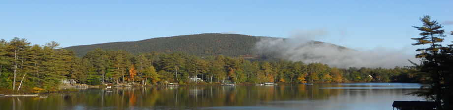
The Association consists of a total of 66 separate properties – 22 on Richardson Shores and 44 on Toltec Point. Raoul’s Cove Path is part of Richardson Shores. There are two land-only properties. There are approximately 1.8 miles of roads in the Association, and the Association includes property on both Hanson Cove and Raoul’s Cove.
Where does the annual meeting take place?
The meeting traditionally takes place at the President’s house. Currently that is the Sullo residence at 83 Richardson Shores. The meeting starts at 9:30 AM and usually lasts one hour. Donuts and coffee are served. It’s a great chance to meet your neighbors. A notice is sent to you each spring with the actual date.
How does the Association care for the roads?
The roads are typically serviced 3 times a year – in the spring, mid-summer and fall. Generally the spring servicing is carried out in May prior to Memorial Day for the start of the summer season, and the fall servicing is carried out in November prior to Thanksgiving for the start of the winter season.
Prior to each servicing the President meets with the road maintenance contractor to inspect the roads and determine what maintenance is required. This maintenance typically involves adding gravel to the surface and grading the roads. Additional service is carried out as needed – for example patching the black-top section or maintaining drainage areas. The brush on the road-side is also cut once every two years in late summer.
Why is the speed limit 15 MPH?
The Association maintains a 15 MPH speed limit on all roads for several reasons. Of primary importance is the safety and well-being of the many children, adults, joggers, bikers, pets and other animals that routinely use the roads. There are a number of blind curves and hills, and several individuals have reported being nearly hit by cars that were traveling too fast over a hill or around a curve.
In addition, a slow speed is critical for maintaining the road surface in good repair. Ruts and potholes, even small ones, once established will grow and multiply if vehicles exceed 10 or 15 MPH. Also, during the dry summer months speeds over 15 MPH contribute to substantial amounts of dust.
For the sake of our Association members and our roads we strongly urge everyone to obey the posted speed limit of 15 MPH. Please note that the speed limit applies to ALL vehicles, including cars, trucks, OHRV’s, snowmachines, and the like.
Why are there so many ruts and pot-holes in the road?
This is a common question and there a number of factors – natural and anthropogenic – that impact the road surface, even though we grade the road twice a year.
The level of precipitation and temperature changes both have a significant impact on the road surface. For example, in 2003 we experienced several heavy downpours following the spring roadwork, effectively re-creating ruts and pot-holes that had just been graded over. Drainage ruts and potholes will arise any time it rains hard enough to flood. Also, in the springtime NH is famous for mud season – that wonderful time of year when it is just warm enough that the surface melts but the underlying soil remains frozen. This results in substantial formation of mud-holes and accumulated water that will not drain.
Human activity also has a substantial impact on the road. This includes normal wear and tear from permitted uses, including regular use by residents, guests, delivery people, contractors and service people. The single most significant factor causing damage to the road is from individuals not obeying the posted 15 MPH speed limit.
We also routinely see damage from vehicles (cars and off-road vehicles) that intentionally spin their wheels and create ruts and holes in the road. We are currently working with the Moultonboro police department to establish mechanisms for reducing the incidence of speeding and intentional destruction of the road surface.
Back to FAQs
What is our relationship with Arcadia Campground?
The Association and Arcadia Campground (now a Condominium Association with a Board of Directors) border each other and share routine use of Hanson Cove. The Association board works to maintain regular communication and maintain our relationship with Arcadia Campground.
Where are the No-Wake Zones and what do they mean?
The Association is effectively bounded by posted No-Wake Zones, including ALL of Hanson Cove and Raoul’s Cove. The Hanson Cove zone extends out to the large rock sitting off of the very end of Toltec Point. New Hampshire marine regulations also require that No-Wake Speed be maintained at all times when within 150 feet of any shore or other marine craft.
A No-Wake Zone requires all marine craft to maintain head-way speed (the minimum speed necessary to maintain steerage) while in the No-Wake Zone.
Click here for the New Hampshire Department of Safety Boating Division web site.
Is there a leash law?
The Association By-Laws do not specifically address leash law regulations. All residents should obey town and state ordinances regarding leashing their pets. However, please remember that an unknown barking dog running out at you on the road as you walk by can be frightening. Please think of others before you let your dog run loose.
Where did Shaker Jerry Road get it’s name?
According to informal town Historian, Ernest Davis, Shaker Jerry Road got its name from a hermit who once lived in a remote cove in the general area of, now, Wentworth Shores. He suffered from palsy, thus was nicknamed, “Shaker Jerry.”
Leave a Reply